3DFBAT file format
Example of 3dfbat file
image size 600 600
open points.dat
method kriging
map fill_contours
save image example_kriging.png
close
open points.dat
method system
map fill_contours
save image example_system.png
close
open points.dat
method distance
map fill_contours
save image example_distance.png
Keywords:
// - comments;
2dview
Create 2D map (default). See
3dview.
3dview
Create 3D map. See
2dview.
array
The input is the matrix data set {Zi,j,k}
(not scattered points). See
points.
array size SizeX
SizeY SizeZ
Set the matrix dimension, if input data set is
matrix. For 2D matrix set
SizeX SizeY 1.
background file
Input the background image.
boundary file
Input the boundary for 2D map.
calibrate PixelX1
PixelY1 PixelX2 PixelY2 CoordinateX1 CoordinateY1 CoordinateX2
CoordinateY2
Calibrate the background image to assign it to the coordinate system.
The example:
calibrate 0 0 763 604
1.5 2.5 2.5 1.9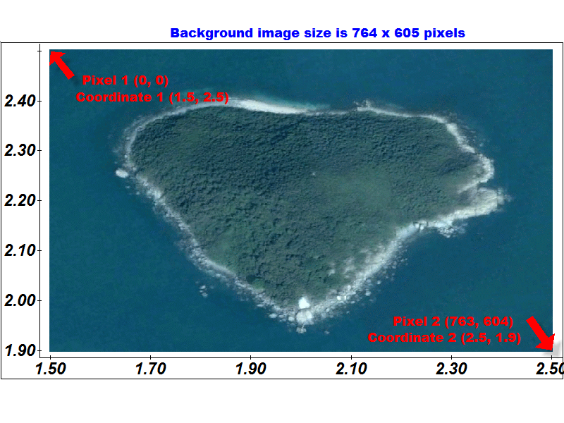
close
Close the map.
color bar {hide | show}
Show or hide the color bar. The default for
color map is show.
color limits Vmin
Vmax
The minimum and maximum limits for the color
bar. The default is auto. For contour map that option don't
works, see contours
levels keyword.
contours levels file
Set the levels for contour map in text file. The example of text level file is (one or a few lines):
1.0 2.0 5.0 7.0
In the default case the levels will been calculated automatically.
drawings file
Load the drawing file. You can create the drawing file in 3DField.
grid size SizeX
SizeY
Set the grid size. The default size is 102 x 102. The margin rows and columns are empty.
grid file
Load the grid file. You can create the grid file in 3DField. In the default case the grid will been created automatically.
method { system | triangulation | distance | kriging |
block_kriging | min_curvature | neighborsi | neighborsii | rbf |
block_rbf | mba}
Set the gridding method. If the gridding method is not specialize, then it get from the setting file.
map
{fill_contours | contours | colcontours | locate_points |
color_cells | color_points | shaded | color_relief |
color_polygons | circle_values | gridding_only}
Set the map to create.
open file
Open the data set in
points (the default)
or array format.
points
The input is the scattered points (the
default). See array.
save {image | grid}
file
Save the map image or the grid digital values
to file.
settings file
Almost all parameters of map is keeping in the
setting file.
Right-click on Map tree item (root) in 3DField and choose
Default the settings command.
You can save the setting file with the changed parameters
as own profile. If
setting keyword is missing then the current setting file
will using.